Horse Hill Overview
Licence numbers: PEDL137 and PEDL246
UKOG interest: 85.635%
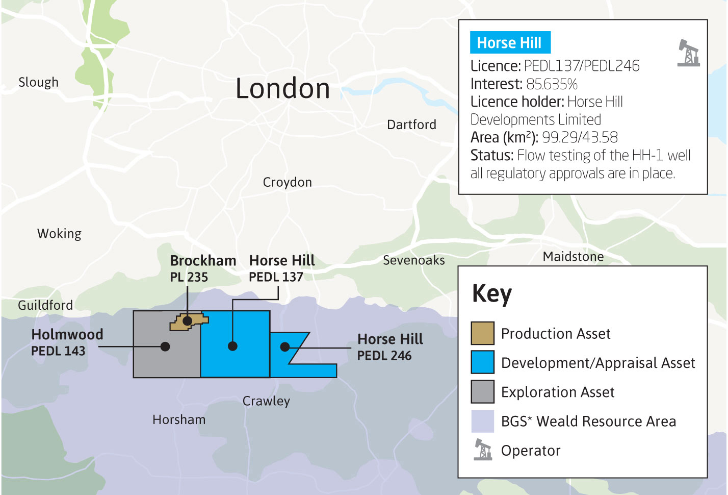
UKOG has an indirect interest of 85.635% in two Horse Hill area licences: PEDL137 and PEDL246. The operator of the licences is Horse Hill Developments Limited (HHDL) Click HERE to visit the HHDL website, in which UKOG has a 42% shareholding. Specific information relating to the Company’s ongoing evaluation of these assets can be found in the RNS section of the website. HHDL has recently flow tested the Portland Sandstone and Kimmeridge Limestone intervals of the Horse Hill-1 (HH-1) oil discovery well.
HH-1 was drilled by HHDL in 2014. The well discovered oil in the Portland Sandstone, as well as in deeper formations including the Kimmeridge Clay, Oxford Clay and Liassic Shale. The well has penetrated and flow tested a significant new oil play in the Kimmeridge Limestone section, together with a potential shale oil play in the Kimmeridge Clay, Oxford Clay and Lias shales.
The Company’s focus for future activities in the licences will be to carry out further extended well tests in the Kimmeridge Limestones and appraise the Portland oil discovery.
HH-1 is located within PEDL137, on the northern side of the Weald Basin near Gatwick Airport. HHDL is a special purpose company that owns a 65% participating interest and operatorship of PEDL137 and the adjacent PEDL246.
Portland Discovery
The HH-1 Portland Sandstone discovery lies within an approximately 100-ft gross thick conventional Jurassic Upper Portland sandstone reservoir, within a 6km by 3km Late Cimmerian age tilted fault block structure and trap, as defined by 2D seismic. The crest of the Upper Portland oil discovery lies at approximately 1760ft true vertical depth subsea and most likely extends over a mapped maximum areal closure of approximately 2000 acres. The Upper Portland reservoir is productive at the nearby Brockham field, some 9km NNW, in which UKOG has an indirect interest of 3.6%, by virtue of UKOG’s 6% shareholding in Angus Energy.
A CPR conducted by Xodus in June 2015 indicates a Best estimate or P50 stock tank oil initially in place (STOIIP) of 21 million barrels (MMbbl) (Table 1). The OIP hydrocarbon volumes estimated should not be considered as either Contingent or Prospective Resources or Reserves.
Table 1: Xodus’ Estimation of Gross STOIIP for the Portland Sandstone
|
Gross STOIIP (MMbbl) |
Low |
Best |
High |
Mean |
|
Upper Portland Gross 100% |
14.3 |
21.0 |
30.4 |
21.8 |
Limestone and Shale Oil Plays
Geochemical analyses of over 250 samples indicate that the HH-1 well penetrated a very thick 1500ft section of world-class, thermally mature, oil saturated source rocks in the Kimmeridge section. The source rock shales encase three Kimmeridge Limestones reservoir units. Further thermally mature shale source rock sections were encountered in the Oxford Clay and Lias shale sections.
Electric log analyses performed by Nutech, utilising all geochemical, and rock calibration points from the HH-1 well, strongly indicate that the Kimmeridge contains a potential oil pay section of over 300ft with a further 73ft of potential oil pay in the Oxford and Lias.
Nutech’s considerable global knowledge base and play library indicates that the Horse Hill Upper Jurassic rock sequence is potentially analogous to known oil productive hybrid reservoir sections of the Bakken of the US Williston Basin, the Wolfcamp, Bone Springs, Clearfork, Spraberry, and Dean Formations in the US Permian Basin and the Bazhenov Formation of West Siberia.
Further recent investigations also indicate that the Kimmeridge Limestones are likely analogous to the Austin Chalk in terms of permeability characteristics and the Eagleford in terms of an oil saturated self-sourcing tight limestone and calcareous shale reservoir unit.
Nutech and Schlumberger have estimated STOIIP for the HH-1 tight Jurassic shale and limestone units, as shown in Tables 2 and 3. Analysis of the wells surrounding and offsetting the Horse Hill licence area and the Company’s other assets in the Weald Basin suggest that a highly significant petroleum resource exists in the basin. The HH-1 and licence area likely lies within the central “sweet spot” of Kimmeridge and Oxford Clay oil in place development.
Table 2: Nutech’s Estimated Tight Jurassic Gross STOIIP for PEDL137 and PEDL246
|
Gross STOIIP, MMbbl |
||||
|
|
Low (P90) |
Best (P50) |
High (P10) |
Mean |
|
Kimmeridge Clay |
1,949 |
5,230 |
8,881 |
5,355 |
|
Corallian |
122 |
556 |
1,384 |
687 |
|
Oxford Clay |
188 |
495 |
908 |
530 |
|
Oolite |
410 |
1,544 |
3,352 |
1,769 |
|
Liassic Shale |
462 |
1,420 |
2,994 |
1,625 |
|
Total * |
3,131 |
9,245 |
17,519 |
9,965 |
|
* Arithmetic sum |
|
|
|
|
Table 3: Schlumberger’s Summary of Estimated Gross STOIIP for PEDL137 and PEDL246
|
Formation |
Mean STOIIP (MMbbl) |
|
Kimmeridge Clay |
8,262 |
|
Oxford Clay |
1,017 |
|
Liassic Shale |
1,714 |
|
TOTAL |
10,993 |
Flow Testing
In February and March 2016, HHDL carried out flow testing of the Portland and Kimmeridge limestone intervals of the HH-1 discovery well.
On 21 March 2016, UKOG reported that the final total aggregate stable dry oil flow rate from the two Kimmeridge Limestones plus the overlying Portland Sandstone was 1688 bopd:
- The final Portland test of 323 bopd, over an 8.5-hour, period is the highest stable dry oil flow rate from any onshore UK Portland well. On further testing, with a larger pump, the rate doubled from the previously reported stable dry oil rate of 168 bopd. The Portland was produced at maximum pump capacity and showed no clear indication of depletion. It is likely that the rate can be further increased using a higher capacity downhole pump during the next planned test
- Proof that the Kimmeridge limestones contain significant volumes of moveable light oil that can be flowed to surface at commercial rates
- As previously reported, the stable, natural dry-oil flow rate of 464 bopd from the Lower Kimmeridge Limestone is the first ever flow from this rock unit in the Weald Basin and onshore UK
- Based on the analysis of published reports from all significant UK onshore discovery wells, the Company concludes that the well’s 1688 bopd is likely to be the highest aggregate stable dry-oil flow from any onshore UK new field wildcat discovery well
- Based on the analysis of published reports from all significant UK onshore discovery wells, the Company concludes that the 901 bopd from the Upper Kimmeridge zone is the highest stable natural dry oil flow rate from a single reservoir in any UK onshore new field wildcat discovery well
- High quality Brent Crude produced: light, sweet oil (40 degrees API in Kimmeridge, 35-37 degrees API in Portland) 1,940 barrels delivered to the Esso Fawley refinery
- Preliminary analysis confirms that the Lower and Upper Kimmeridge Limestone units are naturally fractured reservoirs with high deliverability
- Strong possibility for further optimisation and increased flow rates from all 3 zones in future development and production wells, particularly through the use of horizontal wells.
Summary Table of Test Results
|
Reservoir Interval |
Maximum Instantaneous Oil Rate |
Stabilised Dry Oil Rate |
Perforated Interval |
Stabilised Flow Period |
Depth Below Surface |
|
bopd |
bopd |
ft |
hours |
ft |
|
|
U. Portland 1 |
360 |
323 |
103 |
8.5 |
2000 |
|
U. Kimmeridge 2 |
1008 |
901 |
88 |
4.0 |
2800 |
|
L. Kimmeridge 2 |
700 |
464 |
80 |
7.5 |
2950 |
|
Total |
2068 |
1688 |
271 |
|
|
|
Notes: 1. Flow rate limited by pump stroke rate capacity. 2. Natural flow. |
|||||
Conceptual Weald Basin Oil Development
UKOG, in conjunction with Xodus Group and specialist energy planning and environmental consultants Barton Willmore, has completed a conceptual field development study that investigates the siting of potential drilling and production facilities over the Horse Hill and wider Weald basin area of SE England that could be used to develop a Jurassic oil play in the event it is demonstrated to be technically and commercially feasible.
The prime objective of the study was to investigate at a conceptual level whether potential sites necessary to develop a significant Jurassic oil resource could be constructed with a minimal footprint and visual impact and realistically located in places that would provide minimal impact upon the Weald in order to protect the rural beauty and way of life of the area.